Wednesday, July 31, 2019

Red Deer Lake

Drive & Parking
It'll take a little under 1.5 hours from Denver to get to the trail head assuming you leave early enough to get past Boulder traffic. Once you turn west into the mountains you are on some very curvy two lane roads with a lot of bikers so there is a chance this can slow you down quite a bit.

The last portion and a small middle section of the trip is on a gravel road but they are very well maintained compared to most. The parking lot is a decent size but there are a lot of campgrounds nearby so you'll need an early start if you want any seclusion.

Distance
~14 miles even though we were stupid and went a little over 17

Elevation
Should be around 2,000 but yet again, we were kinda stupid and got lost and did ~2,500. Below is a quick screenshot from my Garmin that shows we blew past the Red Deer Lake turnoff and did a portion of Buchanan Pass Trail


Difficulty
The length in general would make this a fairly difficult trail. There are no technical portions but quite a few sections that are fairly steep. Some of the areas were fairly flooded so we had to share the trail with a lot of water and perform some rock hopping in places. This will vary quite a bit depending on when you go.

The Hike
Like a lot of other hikes this year, it's a steady climb up that follows the Middle Saint Vrain Creek. The creek is very pretty and there are a few waterfall areas that a lot of people walk to that aren't too far from the trail head.

Once you cross the creek, you start to get some better views of the mountains around you, which are very steep.


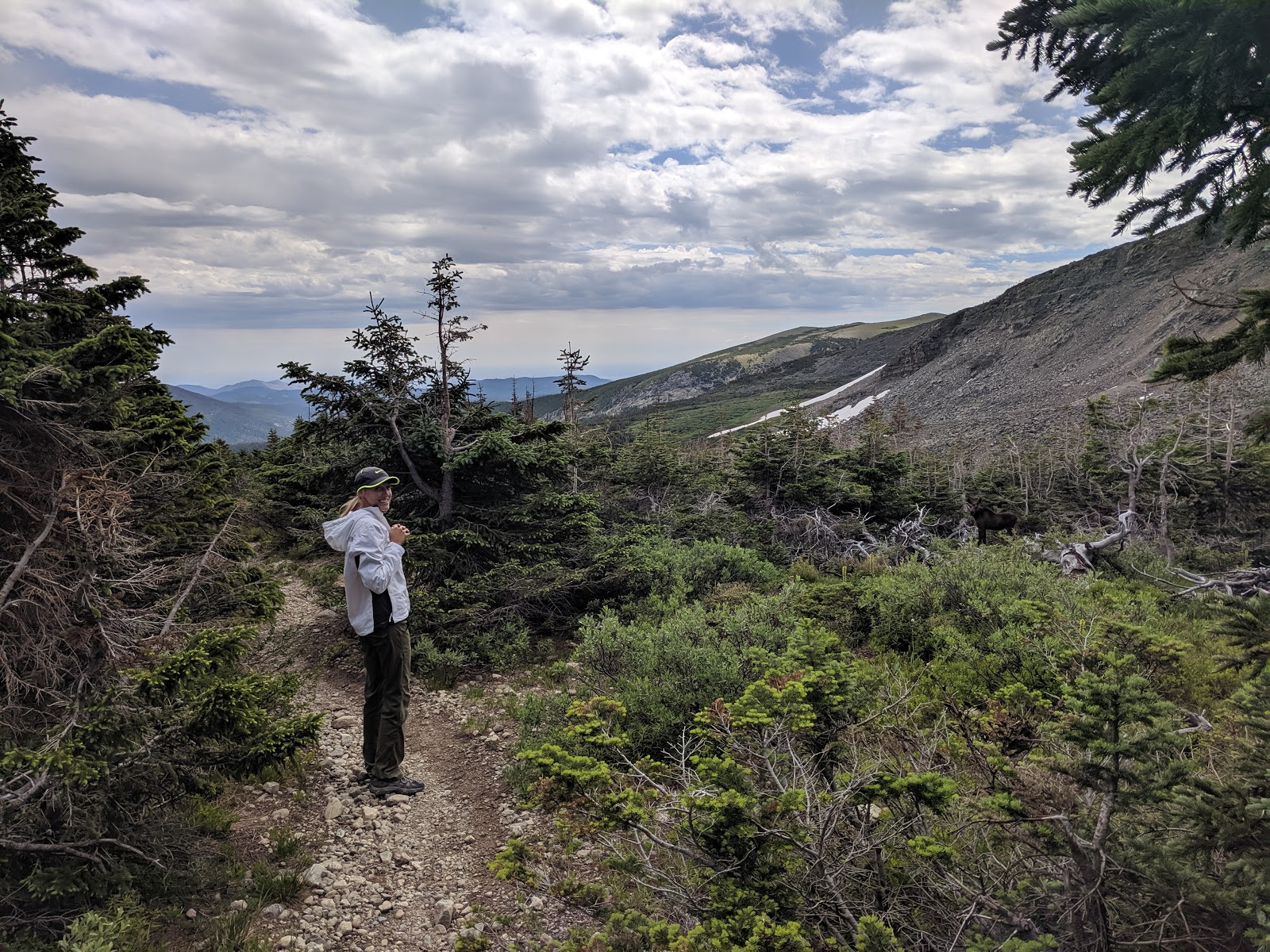
You'll then go through a slightly more wooded area and then have a turnoff to go to the lake to your right. Unfortunately the trail marker was down and it wasn't easy to see so we blew right past it and ended up going to the Buchanan Pass Trail for quite a while. Even though it was tiring, the pass was very pretty with some rolling mountain views. Most importantly, as we were turning around to go back, Ali spotted a baby and momma moose about 20 yards from us. It's hard to see in the picture below but you can see the baby to the right. Btw, Ali was very very excited about this!


As we made our way back down, we saw the portion of the trail that went to Red Deer Lake and took that. This is ~1 mile or so from the main trail and is a solid uphill portion for the majority of it. However, the lake was very pretty and worth the hike up.


Even though it's a long trail, we loved the combination of creeks, lakes, and mountain views. Plus, any time we see a moose it always bumps up the trail quite a bit in our book.

Tanglewood Trail

Drive & Parking
It's about 1 hr. from Denver to the trail head. I don't remember all of the details of the drive since we did this a few weeks ago but I know the parking lot was fairly large and we didn't hardly see anyone there. The last portion of the drive is on a gravel road that has some decent rocks/bumps in it.

Distance
AllTrails says 10 miles, my Garmin marked us at 9.77 miles

Elevation
~2,800 ft. gain with a max of ~8,000 ft.

Difficulty
The trail is uphill the entire way until you hit the saddleback in the last mile or so of the trail. There are no technical or very steep portions, it's just a gradual uphill the entire way. I'd say the trail is moderate with a decent amount of distance.

The Hike
To start, I really enjoyed this trail. It followed a creek for the majority of the time and we fairly shaded which cooled things off quite a bit. It's also very peaceful hiking next to running water and with the lack of people on the trail, you could really get away from everything.

As I mentioned on difficulty, the trail has quite a bit of elevation gain on it so you are going uphill the entire time. The good thing is that it's not very steep, just consistent.

After the first few miles you start to break away from the creek and have a switchback going up the mountain. This is the steepest portion but with the switchbacks, it makes it not as bad. As you continue up, you start to break through the trees which gives you a nice view of some rolling mountains in the distance.


Once you get to the top of the mountain, there is a saddleback that gives you a little level/downhill trip to the lake at the top. For a lake in Colorado, it's a pretty basic one that is more of a pond vs. a lake. Nevertheless, it was still pretty and a nice place to rest. Below are a few pictures of it.


If you continue on for another mile or so, you will eventually hit Roosevelt Lake. We actually did this hike the week before but from a different trail head. While I would recommend Tanglewood, Roosevelt Lakes isn't anything special and the loop we did on the northwest side of it isn't worth the hike in my opinion.

Beaver Reservoir to Coney Lake

Drive & Parking
From the west side of Denver it's a little under 1.5 hours. Assuming you go early enough in the morning, the drive up and through Boulder isn't bad at all. Once you go west on James Canyon Drive, you may get stuck behind some slow traffic as you wind through the mountains.

Parking was kind of weird since there are a lot of camp grounds around there and also you will see "Private Property" signs everywhere. We parked right beside the reservoir on the side of the road before the 4x4 trail starts. There isn't a ton of space here so I'd get there early or you'll have to park around the campgrounds and walk further.

Distance
AllTrails says it's around 12.5 but my Garmin marked us as 11.34 round trip.

Elevation Gain
~1,700 feet with a max of ~10,500

Difficulty
There are no technical or super steep portions of this trail. The only difficult part is the distance.

The Hike
Fair warning, the first 2ish miles of this hike sucks. You are basically sharing a 4x4 road with vehicles and there isn't much to look at. Once you reach a little lake/pond crossing, it becomes significantly better as you are getting into a more wooded area and away from everyone else.


You'll hike another few miles that is slightly uphill and start to get some views of the mountains in the background. While this part of the trail is nice, it's the last 1-2 miles that make this trail. As you start to reach the lake, you will start crossing Coney Creek quite a bit and come across some smaller lakes before you reach the top. This entire area is very pretty and secluded.

About .5 miles from the lake, we ran into quite a bit of snow and had to go off the trail for a while. This shouldn't be a major issue as you basically follow the creek and go straight up. Once you reach the top, you'll have a very nice view of Coney Lake.


As we started to take a little break, we saw two very large bull moose start walking over the snow pack in the top right of the picture above. While that was happened, two cow (female) moose were on the opposite side of the lake drinking water.

We watched them for a few minutes until the bulls got about 30 yards from us and continued to keep coming. So we decided it was a good time to go.

Minus the first two miles of this hike, it was really good. We loved all of the streams and lakes towards the top. The fact that we saw 4 moose and a few elk made it that much better. We also only saw a handful of campers at the lake and hardly no one on the trail head when we started.

Square Top Mountain

I've been slacking big time on posting on here so going to try to do a quick catch up on a few of our most recent hikes. I'm also going to change the format a little bit to make it easier for anyone to quickly look at the page and see relevant information.

Drive & Parking
From the west side of Denver, it was little over an hour to get tot he trail head. The entire road is paved and and pretty straight forward. Once you start getting close to the trail head, you'll probably see 4 million cars all along the road. Don't be worried, all of these people are doing Mt. Bierstadt and not Square Top.

Continue past the madness and there will be a fairly large parking lot with bathrooms for this hike. We got there around 7:30 and only about 25% of the lot was full.

Distance
6.9 miles

Elevation Gain
2,440 feet

Difficulty
I'd say this hike is fairly hard overall. There are only a few sections of the trail where it's very steep but the entire trail is steadily uphill. Between that and it maxing out around 13,794, it adds up quickly. There are not any technical portions of this trail though.

The Hike
The hike starts out with a some little rolls as you start winding towards the bottom of the mountain. There are quite a few little creeks/streams that are around the trail and depending on the weather, you may be be sharing the trail with some of the creeks for portions of the trail.

About half way into the round trip, you'll see one lake right beside the trail and then a branch off to the right that leads to another lake that isn't as visible from the main trail. As the day goes on, this area will get fairly busy as a lot of people don't complete the full hike but just go to the lakes.

After the lakes, the gradual uphill becomes quite a bit steeper. There aren't any switchbacks on this one so it's pretty much a grind straight up. As you get towards the top of the mountain you have some pretty views of the lakes below. In the picture below you can see both of them as well as the road in the background. The trail head is straight ahead over the hill.


After a what feels like a long time of uphill, you finally reach the sudo top of the mountain and can see a few additional lakes on the east side.


You then have a slightly more rocky but less steep climb to the very top of the mountain. Overall, the summit area is very large and there is probably only 100 feet or so if elevation difference from one side vs. the other.


All-in-all, I'd say it's a pretty good hike to do. A lot of the 14ers are overrated and way too crowded. This 13er will give you almost everything Mt. Bierstadt would. The entire trail is exposed so it wouldn't be ideal on a very hot or windy day. But it does give you a good mixture of lakes and views.

Splunk's Adaptive Response Framework

Before I start this post, I want to give a quick shout out to Splunk. I recently just got back from my first .conf and I have to say, overal...